

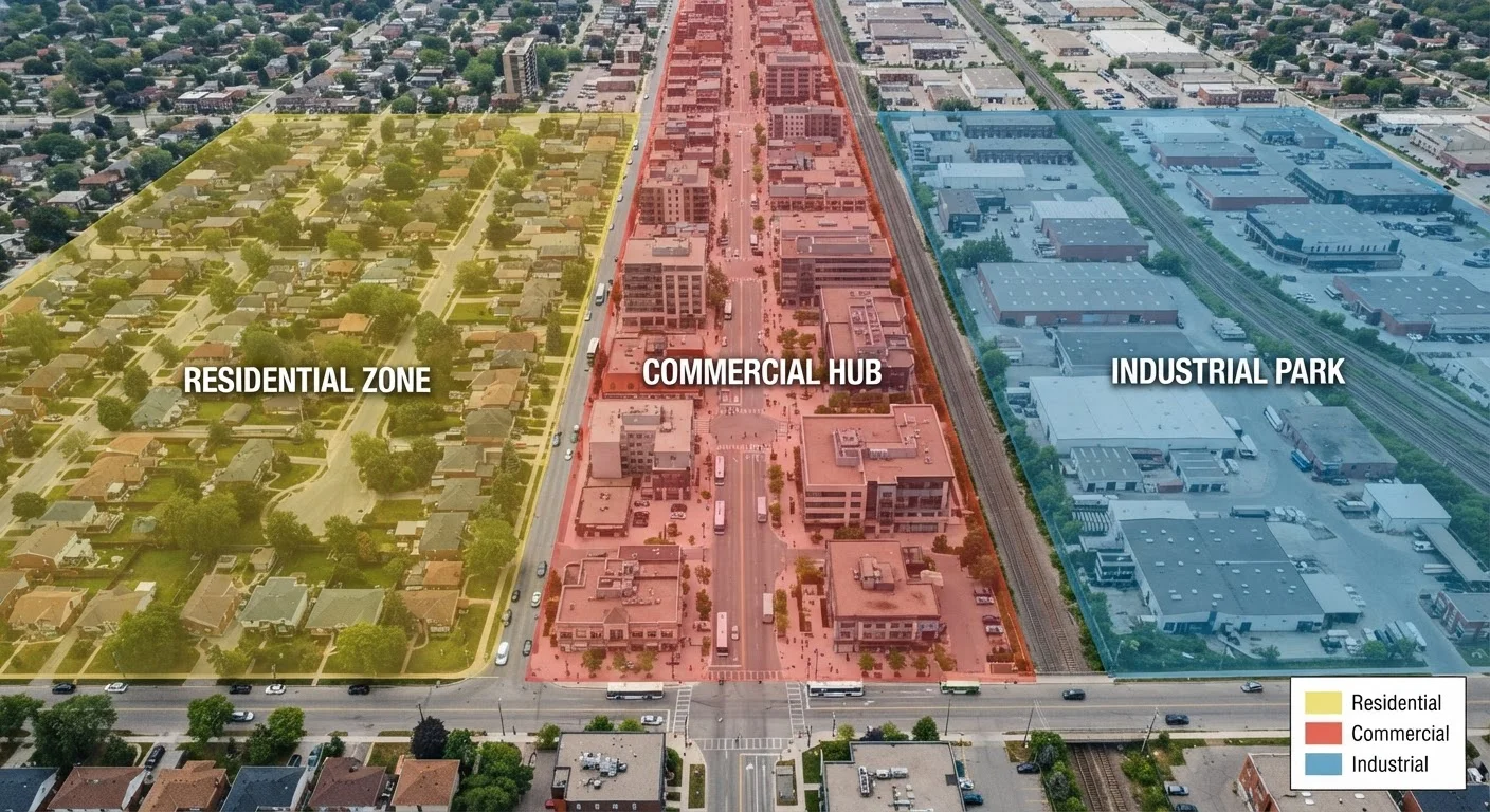
How Zoning Works: The Basic Framework
Every municipality that has adopted a zoning code maintains a zoning map — a document that assigns a classification to every parcel of land within its boundaries. Alongside the map sits the zoning ordinance, a legal text describing what each classification allows, prohibits, and conditionally permits.
When a developer, architect, or landowner wants to build something, the first question is always: what does the zoning allow here? The answer determines the entire scope of what is possible before a single design sketch is drawn. Misunderstanding or ignoring zoning at this stage is one of the most costly mistakes in property development. For a broader look at how projects take shape from the ground up, see Property Development Explained.
30,000+
U.S. local governments with zoning authority
Zoning is administered at the local level; the National League of Cities estimates tens of thousands of municipalities maintain their own zoning codes.
75%+
Residential land zoned exclusively single-family in many U.S. cities
Research from urban planning academics has found that a majority of residential-zoned land in many American cities is restricted to single-family use, limiting density options.
2–5 years
Typical timeline for a major rezoning approval
Complex rezoning petitions — especially those requiring environmental review or comprehensive plan amendments — can take multiple years to resolve, according to urban planning practitioners.
Common Zoning Classifications Explained
While terminology varies by municipality, most U.S. zoning systems share a recognizable set of categories:
- Residential (R): Governs housing. Subcategories distinguish low-density single-family lots from higher-density townhomes or apartment buildings.
- Commercial (C): Covers retail, office, restaurants, and similar uses. Intensity typically increases from neighborhood-scale (C-1) to regional commercial (C-3 or higher).
- Industrial (I or M): Ranges from light manufacturing and warehousing to heavy industrial operations, with different buffering requirements from residential areas.
- Agricultural (A): Preserves farmland and rural uses; often restricts subdivision and non-farm structures.
- Mixed-Use (MU): Intentionally blends residential and commercial — and sometimes light industrial — uses in the same zone or building. Mixed-use development has grown in popularity as cities pursue walkable, transit-oriented neighborhoods.
Zoning vs. Deed Restrictions: Not the Same
Zoning is a government regulation enforced by public authorities. Deed restrictions (also called restrictive covenants) are private contractual limitations attached to a title. Both can constrain how a property is used, and both must be reviewed during due diligence — but they operate through entirely separate legal frameworks. A property can comply with zoning yet still be subject to stricter private restrictions.
Dimensional Standards: More Than Just Use
Zoning regulates far more than what a building is used for. Dimensional standards control the physical form of development and typically include:
- Setbacks: Minimum distances a structure must stand from property lines, roads, or other features.
- Height limits: Maximum allowable building height, sometimes expressed in stories, sometimes in feet.
- Lot coverage: The percentage of a parcel that can be covered by buildings or impervious surfaces.
- Floor Area Ratio (FAR): The ratio of total building floor area to the lot area — a key lever controlling density.
- Parking minimums: Required off-street parking spaces per unit or per square foot of use.
These standards shape neighborhood character as much as use restrictions do. A zone that allows multi-family housing but caps FAR at 0.5 will produce a very different built environment than one that caps it at 3.0.
When Zoning Doesn't Fit: Variances, Rezoning, and Overlays
Zoning is not immutable. Developers and property owners have several formal mechanisms to work within or modify existing rules:
Variance: A site-specific deviation from dimensional or use standards, granted by a zoning board of appeals when literal enforcement would create undue hardship. Variances do not change the underlying zoning classification.
Rezoning (Map Amendment): A formal request to reclassify a parcel to a different zone. This is a legislative act — typically voted on by a city council or county board — and carries a higher bar. Local governments generally evaluate rezoning petitions against their adopted comprehensive or general plan.
Conditional Use Permit (CUP): Allows a use that is permitted in a zone only under specific conditions — a drive-through restaurant in a commercial zone, for example, may require a CUP with traffic-flow conditions attached.
Overlay Districts: Additional regulatory layers applied on top of base zoning — common examples include historic preservation overlays, flood-plain overlays, and transit-corridor overlays. These add requirements or permissions without changing the base classification.
Site selection for development projects must account for all of these layers. Whether a site is raw land or a parcel being redeveloped, zoning determines feasibility. Choices between greenfield and brownfield sites, for instance, often involve significantly different zoning starting points — see Greenfield vs. Brownfield Development for how those differences play out in practice.
Confirm Zoning Before Purchasing Land
Always verify a parcel's current zoning classification and any pending amendments before signing a purchase agreement. Most municipalities publish zoning maps online, and a pre-application meeting with planning staff can surface entitlement risks early. Building contingency time for zoning approvals into your project schedule is standard practice for experienced developers.
Zoning's Role in the Development Team
Navigating zoning is rarely a solo effort. Most development teams include specialists whose job is to interpret and engage with local land-use regulations. Land-use attorneys review entitlement risks, while planning consultants liaise with municipal staff and prepare variance or rezoning applications. Architects must design within zoning envelopes from the earliest concept stage.
Understanding who is responsible for zoning compliance at each project phase is part of building a capable development team. The roles involved in a property development project explains how planners, architects, and other professionals each contribute to moving a project through entitlement and into construction.
This article is for general informational purposes only and does not constitute legal, financial, or professional planning advice. Zoning regulations vary significantly by jurisdiction. Consult a licensed attorney, land-use planner, or local planning authority for guidance specific to your situation.